Newsletter of the College of Architecture at Texas A&M University
Ann Moss Joyner, an author who uses geographic information systems to illuminate racial discrimination issues that inform her research, will be the keynote speaker for Texas A&M University’s GIS Day — a campuswide celebration showcasing real-world applications for GIS technology.
Joyner’s lecture, “Using GIS to Fight Racial Inequality,” is set for 6 p.m. Tuesday, Nov. 15 in the Preston Geren Auditorium, located in Building B of the Langford Architecture Center on the Texas A&M campus. A reception for Joyner will be held 5:30 p.m., prior to the lecture, which is sponsored by the College of Architecture’s Hazard Reduction and Recover Center and Texas A&M University Libraries.
A full schedule of GIS Day events will be held across campus on Wednesday, Nov. 16. Activities include immersive 3-D visualization demonstrations sponsored by the Immersive Visualization Center, located in Room 260 of the Halbouty Geosciences Building; GIS demonstrations at the West Campus Library, 10 – 11:30 a.m.; and GIS activities including a student poster exhibition and lightning rounds, with a chance to win a $100 gift card, at the Evan’s Library, 12:20 – 3 p.m.
Details and event schedules will be posted on the Texas A&M GIS Day website.
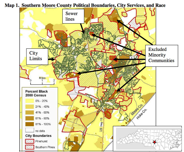
In her GIS Day keynote address, Joyner will discuss her work as president and co-founder of the Cedar Grove Institute for Sustainable Communities, Inc., a nonprofit organization based in Mebane, North Carolina. She will demonstrate how GIS maps reveal that city boundaries in numerous southern towns have been drawn to exclude minority communities. This practice, she said, results in lower levels of services, reduced access to infrastructure and a limited or nonexistent political voice in land-use and permitting decisions.
GIS maps produced by the Cedar Grove Institute played a vital role in a federal jury’s 2008 decision to award more than $10 million in damages to African-Americans in Ohio’s Muskingum County who, despite nearly five decades of requests, had no water service.
In a December 2009 article, “The Revolution Will Be Mapped,” published in Miller-McCune magazine, writer Bob Burtman reported on the case.
“We could articulate the case in words,” civil rights attorney Reed Colfax told Burtman. “But when you’d put up the maps, they’d stop listening to you and look at them (as if to) say, ‘Is this really possible?’”
Joyner received a B.A. from New College and an M.B.A. from the University of North Carolina – Chapel Hill. She is co-author of “Minority Exclusion in Small Town America,” a report published by the Poverty & Race Research Action Council; “Racial Apartheid in a Small Southern Town,” published by the Review of Black Political Economy and “Standards for Extending Extra-Territorial Jurisdiction: Written in Black and White?”
Currently, Joyner is co-investigator for a study “Racial Segregation in Small Southern Towns,” funded by the National Institute of Child Health and Human Development. The study examines the nature and effects of racial segregation that are created and maintained by local political geography.
To learn more about the impact of GIS technology on the world, visit the national GIS Day website.
- Posted: Oct. 6, 2011 -
Contact: Phillip Rollfing, prollfing@archone.tamu.edu or 979.458.0442.

Ann Moss Joyner