Newsletter of the College of Architecture at Texas A&M University
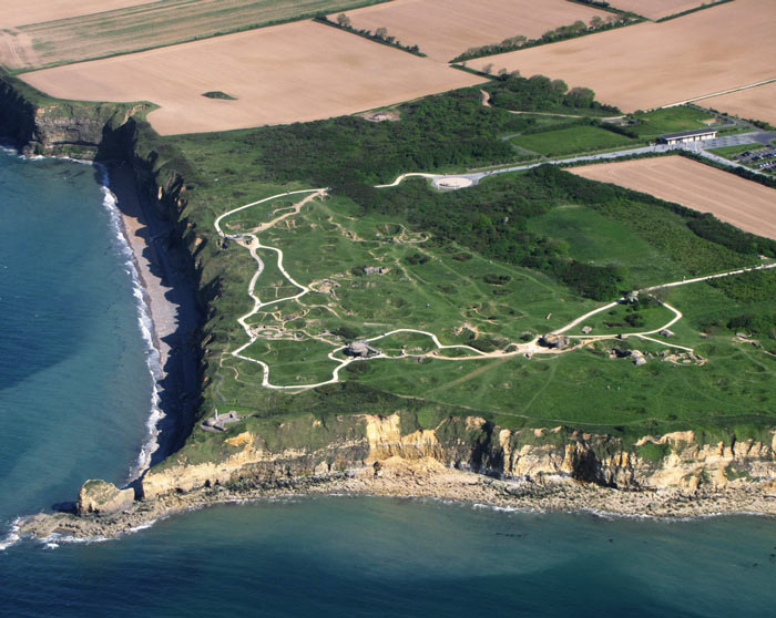
Pointe du Hoc in Normandy, France, one of World War II's most important battlefields and a source of pride for Aggies everywhere, will reopen to the public this fall following a $6 million restoration, now under way, based on information gathered by the Texas A&M College of Architecture’s Center for Heritage Conservation.
On D-Day, June 6, 1944, U.S. Army Rangers under the command of Lt. Col. Earl Rudder, a future president of Texas A&M, performed one of the war's greatest feats, scaling Pointe du Hoc's 90-foot cliffs then defeating intense German counterattacks, helping secure an Allied victory.
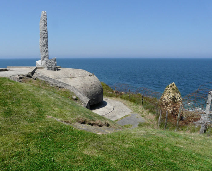
A memorial on the battlefield, built to honor the achievement of Rudder's Rangers, has been closed to the public since 2001 because of fears it could fall into the sea; it sits on unstable cliffs, laced with caverns, that receive a daily pounding by wind and waves from the English Channel.
U.S. Rep. Chet Edwards, a Texas A&M former student who championed the effort to save the endangered battlefield memorial, secured funding for the CHC research team to analyze the site, identify the problems and make recommendations. The two-phase study, led by Robert Warden, CHC director and professor of architecture, Jean-Louis Briaud, professor of civil engineering, and Mark Everett, professor of geology and geophysics, provided details that enabled engineers to stabilize the cliffs and rescue the ranger memorial.
"We're not only going to be able to save Pointe du Hoc for the ages, but after a decade of visitors not being able to visit this incredibly hallowed ground, it will once again be opened up, we hope, as early as this September, to visitors throughout the United States and throughout the world," Edwards announced in a April 27, 2010 press conference.
AGGIES TO THE RESCUE
The plight of the ranger memorial was initially identified by Texas A&M researchers in 2004, when a team from the College of Architecture’s Historic Resources Imaging Laboratory, which later became the CHC, began documenting the site to gain a better understanding of the historic battle in a study funded by the National Center for Preservation Technology.
It was David Woodcock, a professor of architecture at Texas A&M who was then director of the HRIL, who in 2006 brought the critical problem to Edward’s attention. In response, Edwards initially secured a $434,000 grant for to expand the Pointe du Hoc study and determine the causes of the cliff’s instability.
Those funds were initially awarded to the American Battle Monument Commission, which maintains U.S. military monuments and markers in foreign countries. With Edwards’ recommendation, as well as support he garnered from the U.S. Army Rangers and the Rudder family, the CHC team was selected by the ABMC to conduct the study.
HIGH TECH TOOLS
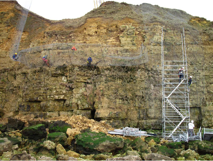
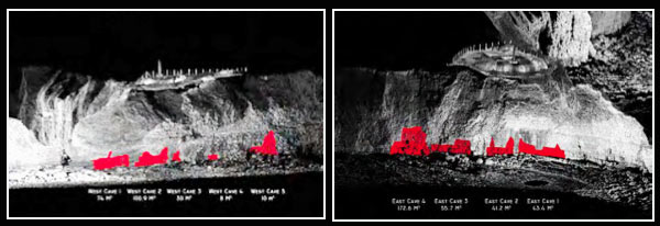
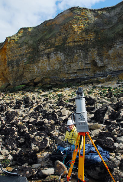
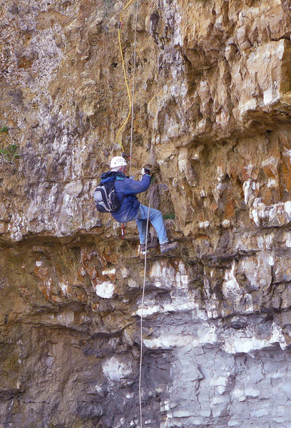
The Texas A&M researchers employed various 3-D imaging tools and techniques, such as a total station and photogrammetry, conducted resistivity tests and took core samples of the site to determine that caverns beneath the cliffs were contributing to their instability.
The total station utilizes a laser distance meter that can measure the distance to a point of interest — usually objects like corners of buildings, windows, doors, or ornaments. With a distance measurement and a known angle, a surveyor can calculate the x,y,z, coordinate value for each point. These coordinates are then transferred from the total station to a computer and used in a CAD program, like AutoCAD, to produce 2-D drawings or 3-D models.
Photogrammetric equipment includes cameras, scanners, computers, specialized software and plotters. These can be used with the total station to increase the accuracy and precision of measurements.
The resistivity study, conducted by Everett, revealed groundwater and cavern locations. Resistivity tomography involves running a low-voltage charge between electrodes strung along electric lines and measuring its variations to determine the soil's resistance.
The team used core samples to analyze the strength of the site's soil.
THE SOLUTION
Ultimately, the researchers determined that caverns honeycombing the cliff rocks were undermining the structural integrity of site.
"There is no doubt in our mind that the single most important part of any remediation of the cliff erosion is to backfill the caverns at the cliff base," wrote Briaud, Hamid Reza Nouri and Colin Darby, civil engineering graduate students on the CHC team, in the study's final report.
The caverns were formed, said Warden, by the effects of rainwater.
"In a nutshell, rainwater dissolves the limestone, which forms caverns and loosens rocks," he said. "Then you have the mechanical action of the sea that pulls big stones out. When a cavern gets big enough, you get a failure of the cliff."
The team presented its findings to the ABMC, recommending a second phase of study focusing on the erosion’s effects on the observation post and Ranger memorial.
Edwards again came through, garnering an additional $361,000 for the project in 2008.
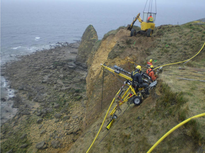
After collecting site specific data during the study's second phase and identifying specific threats to the memorial, the team hired consultants from of two of the world's leading geotechnical construction companies who recommended that micropiles, or concrete columns, be placed 130 feet into the bedrock underneath the observation post to stabilize it.
The next phase of the project, the site's stabilization by France's GTS Group, began February 2010.
Once again, Chet Edwards was instrumental to the project's progress, as the appropriations subcommittee he chairs funded the $6 million remediation.
GTS has been approaching the task in four phases:
GTS is also installing equipment that will measure geological and hydrological information at the site for several years.
"We're really excited about all the work going on now and can't wait to see the results," said Warden during Edwards' April 27 press conference.
VIEW THE PROGRESS, LEARN THE HISTORY
The restoration effort can be followed online at www.travaux-pointeduhoc.com/ where photos, videos and news of the project are regularly updated.
Edwards' press conference announcing the scheduled opening this September of the much hallowed and long inaccessible ranger memorial site can also be viewed online at YouTube.
An interactive multimedia narrative of the historic battle at Pointe du Hoc, which was characterized by Allied Forces as “the single German Defense position most dangerous to their invasion plans,” is available on the American Battle Monuments Commission's website.
See a previous archone. story with photos detailing the CHC’s 2008 research trip to Pointe du Hoc.
- Posted: June 18, 2010 -