|
In August 2002, scientists from Texas A&M University's Hazard
Reduction & Recovery Center were invited to São Paulo, Brazil
to participate in a civil defense training workshop and evaluate
Brazilian civil defense programs for flood and landslide mitigation.
"They wanted us to look at what they do," said Carla Prater, an
HRRC research scientist who was joined on the trip by Michael
Lindell, the HRRC director. "We went to study both their technical
system and the Brazilian emergency management system in general."
The trip included visits to riverside cities like Registro, Eldorado
and Jundiaí, which are vulnerable to flooding and landslides.
The A&M scientists also met with geologists and engineers at the
University of São Paulo who are working on landslide and flood
prediction systems.
Along their way, the A&M team attracted considerable press attention,
due in part to Prater's fluency in Portuguese.
"Carla's language skills were very critical to the success
of our trip," Lindell explained. "To the Brazilians,
a Portuguese-speaking gringa was quite a novelty. She opened
quite a few doors for us and as a result, we got to see areas
of São Paulo and visit with people that we might otherwise have
missed."
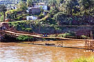
In Registro, about 189 kilometers southeast of São Paulo, the
A&M team toured floodplain areas along the Ribeira de Iguape River.
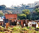
There they found the residents most at risk to flooding were poor
squatters who, often dependent on the river for survival, had
built settlements on its flood-prone banks. To mitigate this threat,
the city had constructed quality, low-income housing for the riverside
residents, but because the housing was far from employment and
commerce, most of the squatters eventually returned to live in
hazardous areas.
To address this problem, the city made the low-income housing
more attractive by paving roads and introducing social programs.
They also implemented neighborhood-level civil defense committees.
"Initially, the Brazilian's plan had not addressed the social
issues involved in evacuations," Prater said, but they are moving
quickly to remedy their mistakes. "Fortunately they're doing it
right. They haven't made a lot of mistakes other countries make."
The observations the A&M team made in Registro were similar to
their findings in Eldorado and Jundiaí.
Below is chronological summary of Lindell's
and Prater's Aug. 6-18, 2002 trip to São Paulo. Brazil.
Report on Aug. 2002 trip to
State of São Paulo, Brazil
By Mike Lindell and Carla Prater
Hazard Reduction and Recover Center
College of Architecture, Texas A&M University
Wednesday, August 7, 2002
The Hazard Reduction and Recovery Center team arrived in São Paulo
on Wednesday August 7 and were transported by Captain Luiz Dias
to the offices and residence of the governor of the state of São
Paulo, the Palácio dos Bandeirantes, where the offices of the Coordenadoria
Estadual de Defesa Civil (CEDEC) are located.
At the CEDEC, Carla Prater delivered a 45-minute presentation
on the Hazard Reduction & Recovery Center. Colonel Roberto Allegretti,
the state civil defense coordinator, followed Prater with a 45-minute
presentation on the activities of CEDEC. The rest of the day was
spent touring the CEDEC headquarters. The meteorologist in their
Emergency Operations Center explained their flood warning system.
Thursday, August 8, 2002
On Thursday the HRRC scientists traveled to Registro, a flood
prone city on the Ribeira do Iguape River, about 189 kilometers
southeast of São Paulo. The city has a population of about 50,000.
In Registro, the chief engineer of the local watershed management
agency showed the A&M team how the state-wide flood warning system
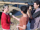
operated along that stretch of the Ribeira do Iguape River. Prater
repeated her presentation about HRRC and was interviewed by the
local newspapers.
After lunch the scientists toured two segments of the floodplain
that presented recurrent problems for city and state agencies.
In both locations the occupants of squatter settlement that had
built up over time were relocated to casas populares - good quality
low-income housing - and the settlements in the risk areas were
demolished. This new housing was located in an area well away
from the river but also much farther from the center of town.
Consequently some of the favelados returned to rebuild in the
risk area. Over time they were joined by others - some who moved
in from rural areas and others who were from Registro and wanted
to remain close to their families but could not afford conventional
housing there.
City agencies have been partially successful in coping with this
problem by increasing the attractiveness of the casas populares
by providing paved roads, a community center and job training
programs for both men and women. The city has also created an
evacuee shelter program by constructing an exposition hall that
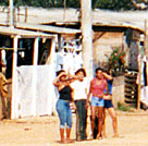
has a roof but no walls. When the risk areas flood, the residents
are relocated to the shelter area where heavy plastic is draped
from the roof to form walls. Evacuee families partition the enclosed
area with their furniture and other belongings to provide personal
privacy.
An advantage of using the fairground is that the city has a legitimate
reason for evicting those favelados who find the temporary shelter
to be quite acceptable as permanent living quarters. When time
for the regularly scheduled events that utilize the exposition
space comes near, the city has a publicly acceptable rationale
for evicting the homesteaders.
Friday, August 9, 2002
On Friday the HRRC scientists traveled to Eldorado, population
14,500, which is located approximately 60 kilometers upstream
from Registro on the Ribiera River. Because it is located farther
upstream, Eldorado has less warning about major floods originating
at the head of the river. It is also located near the foot of
the mountains, so the river valley is very narrow there. Consequently,
a major flood had recently crested about 45 feet above flood stage
inundating most of the town lying between the river and the city
hall. The flood washed away an important bridge that was in the
process of being reconstructed at a higher level when the A&M
team arrived.
In the wake of the flood, the prefeito (mayor) was seeking funds
to raise the levee along the river to 11 meters. Though the height
would not have been sufficient for the most recent flood - the biggest
in the 175-year history of the town - 11 meters would be sufficient
for more common floods that typically rise only to 10 meters. In
the meantime, residents of the most vulnerable areas in Eldorado
contend with flood threats by evacuating themselves and their belongings
to a community center located about one block away and five meters
higher. As in Registro, the Eldoradan evacuees set up partitions
that divide the community center into family units. At the end of
our tour, a regional television reporter from Rede Globo in Santos
interviewed Prater, the prefeito and Captain Dias.
Monday, August 12, 2002
On Monday the HRRC team met with researchers from two laboratories
at the main campus of the University of São Paulo. The first group
was in a geological laboratory that is developing a landslide prediction
system. These researchers have developed hazard maps of the entire
state of São Paulo, but have emphasized the coastal mountains where
the landslide threat is the most severe. Their landslide prediction
system is based upon rainfall measurements (both by radar and rain
gauges) that are used to make preliminary predictions of landslide
locations.
Because the risk areas are as much as a three-hour drive from
the university, local teams have been trained to inspect slide-prone
areas for indications of slippage. The checklist of indicators
provides a qualitative basis for making evacuation recommendations,
but quantitative predictions of slide probability will not be
available until an adequate amount of data has been collected
over the next few years.
The second laboratory was hydrological engineering laboratory responsible
for developing a network of rain and stream gauges used in São Paulo's
flood warning system.
Tuesday, August 13, 2002
On Tuesday, the team visited Jundiaí, a medium-sized city with
a population of about 323,000, about 50 km north of São Paulo.
Jundiaí is a prosperous city with some industry located down slope,
and thus usually downwind, of the city.
Because of its favorable economic conditions, Jundiaí has only
a few small favelas, or squatter settlements, although as in the
other cities visited, these are located in flood plains that have
been avoided by all but the very poorest residents. As was the
case in Registro, the Judiai authorities built casas populares
and relocated the favelados from the risk areas. The casas populares
were located just across the road from the favela so there was
no problem with returnees, but the supply of favelados was so
large that the squatter settlement was completely reconstructed
within days of its demolition by the authorities.
In Jundiaí, the A&M scientists accompanied a large delegation from
Defesa Civil in a lengthy meeting with the prefeito. Carla Prater
was interviewed in Portuguese by reporters from the local television
and radio station. The A&M team also appeared in a front page article
in one local newspaper and in a long article in another local paper.
Wednesday, August 14, 2002
On Wednesday the HRRC scientists participated in a civil defense
training workshop for 200 civil defense employees and volunteers
in Rio Claro, a city about 175 kilometers northwest of São Paulo
with a population of about 160,000.
A local television station interviewed Prater and Lindell offered
welcoming remarks (translated by Prater) along with Colonel Allegretti
and the prefeito of the city. During the afternoon the scientists
were led on a tour of the local campus of the University of São
Paulo by the president, a nuclear physicist who headed the response
to the 1987 radiological contamination incident at Goiânia. As a
consequence of that experience, he was very interested in civil
defense and said he plans to invite the A&M team to return to help
his campus build its teaching capabilities on this subject.
Thursday, August 15, 2002
On Thursday morning, Prater made yet another presentation on the
HRRC and its work in hazard mitigation at the civil defense training
workshop. The presentation generated many questions from the audience,
and a great deal of interest was expressed in having HRRC staff
return to offer more extensive training in emergency management
and mitigation techniques.
In the afternoon, the A&M team visited a state park developed
from an old eucalyptus plantation that was started by the railroad
in the early 20th century. The railroad was privatized, but the
plantation was kept as public land and is being restored as a
state park with a mix of local, state and federal funds. They
then returned to participate in the closing ceremony for the workshop,
and received certificates for participation.
Friday, August 16, 2002
Friday, the Aggies left Rio Claro and traveled 64 kilometers to
São Carlos, population 185,000, where they visited the local Comissão
de Defesa Civil (COMDEC) installations. They were joined by Colonel
Allegretti and had lunch with the local Rotary Club. Prater and
Allegretti were interviewed by the local affiliate of the Jovem
Pan radio network, and then toured the new Transportes Aéreas
de Marília airplane repair facility and a Tecumseh compressor
manufacturing plant.
Friday evening the group attended a graduation ceremony for the
new volunteers for the São Carlos COMDEC, and then returned to
São Paulo.
Saturday, August 17, 2002
The HRRC team returned to College Station.
| |
|