| |
A&M preservation team
documents cliff dwelling
 Aggie preservation team adds Montezuma Castle to
Historic American Buildings Survey
Aggie preservation team adds Montezuma Castle to
Historic American Buildings Survey
| |
|
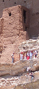
Twelve adventuresome A&M graduate students joined architecture professors Bob Warden and David Woodcock in the summers of 2002 and 2003 to survey and document Montezuma Castle, a prehistoric cliff dwelling nestled into a limestone recess high above the flood plain of Beaver Creek in Arizona's central Verde Valley.
On the mission, described by Woodcock as a "mixture of daring and caution," the Aggie teams found themselves clambering up a 130-foot cliff, working in afternoon temperatures of up to 110 degrees, and dodging curious tourists who did everything from applauding to squawking "get out of my picture!"
The mission was A&M's Historic Imaging Resource Laboratory's second
historic landmark documentation assignment for the National Parks
Service's Historic American Buildings Survey — an opportunity
HRIL director David Woodcock called an "always rare and special
event." The 2002 team, including five architecture students and
a civil engineering student, was joined by A&M graduate Lauri Floth
McNeill '98, who currently practices architecture in Phoenix, Arizona.
Montezuma Castle is one of the best-preserved cliff dwellings in
North America. The five-story, 20-room stone and mud-mortar structure
was built around 1200 AD. It served for about 200 years as a "high-rise
apartment building" for the prehistoric Sinagua Indians who mysteriously
disappeared about 600 years ago. A mistaken conclusion by early
Spanish explorers led to the dwelling's historic misnomer: it is
not a castle and famed Aztec leader Montezuma had nothing to do
with its existence. In fact, the cliff dwelling was abandoned almost
a century before Montezuma was born.
Although archaeologists had studied the structure as early as the
late 1800s, no architectural drawings of the building existed prior
to the A&M mission. To create an historical document, project leader
Bob Warden instructed the teams in a variety of survey and drawing
techniques. They utilized high-tech photogrammetry and total station
theodolite survey methods as well as meticulous hand measuring.
"Theodolites and total stations are instruments used to measure angles very accurately," Warden explained.
The total station utilizes a laser distance meter that can measure
the distance to a point of interest — usually things like corners
of buildings, windows, doors, or ornaments. With a distance measurement
and a known angle, the surveyor can calculate the x,y,z, coordinate
value for each point. These coordinates are then transferred from
the total station to a computer and used in a CAD program, like
AutoCAD, to produce 2-D drawings or 3-D models.
Photogrammetric equipment, on the other hand, includes cameras, scanners, computers, specialized software, and plotters. These can be used with the total station to increase the accuracy and precision of measurements. The A&M team used 35mm SLR film cameras and digital cameras along with "Photomodeler," a photogrammtery software application from EOS Systems, to create 3-D models from photographs.
Once collected, the Montezuma Castle measurements were interpreted
into accurate, highly detailed architectural drawings on Mylar sheets
meeting the exacting standards of the Historic American Building
Survey. The drawings will be stored for perpetuity in the Library
of Congress where they provide a public resource for the ongoing
management and study of this important national treasure.
The exacting nature of the Aggie team's work was made more challenging by Montezuma's special conditions.
"The first order of business each day was getting the documentation team up the 60 vertical feet to the entrance of the building," Woodcock said. "Using one ladder, we scaled the cliff in three legs, pulling the ladder up with us each time to prevent unauthorized ascents."
While the first few ascents were "kind of precarious," the task
of working on the side of a cliff soon became business as usual,
according to Jeff DeHaven, one of the architecture students working
on the project. The group's first climb to the site took 20 to 30
minutes; the record was 8 minutes, 45 seconds!
"It's really hands-on work that's fun and interesting," DeHaven said. Although he had done some field measuring on previous historic documentation projects, contending with the heat, dust, and even bats at the Verde Valley site, he said, was "vastly different."
To complete the HABS documentation of the Castle, a second team of six A&M graduate students returned to the project site with Warden this summer. When done, Warden said, the final set of drawings will consist of 35 24" x 36" Mylar sheets.
"The Castle," as it's become known, was designated as a national landmark in 1906 by President Theodore Roosevelt. It was the first prehistoric site to earn such a designation. For many years, visitors were allowed to climb ladders up and into the pre-historic structure, but in the 1950s, heavy tourist traffic prompted the National Park Service to limit viewing to an area at a distance below the cliff.
Plans call for the precise measurements and drawings completed by the A&M team to be used in the creation of a detailed, interactive 3-D model. Warden said HRIL is currently writing proposals for grants to cover the development of the interactive model, as well as the study of graffiti and petroglyphs at the Castle site.
When completed, a 3-D, walkthrough model of Montezuma Castle could be displayed at a tourist center, allowing visitors to peek into the structure's interior. According to National Park Service statistics, Montezuma Castle attracts between 800,000 and one million visitors annually.
The thousands of tourists who visited Montezuma Castle during the A&M team's survey took home their own record of project: snapshots of Aggies scaling ladders, planting red surveying flags, or humoring the tourist by waving and posing.
DeHaven mused about his summer of celebrity gained perched on the
ledge with the historic landmark: "Our group will be in — basically
everyone's — summer photos."
| |
|
|
| |
|
|