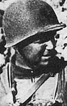
On June 6, 1944, Colonel James Earl Rudder, who would later become president of Texas A&M University, led elements of the U.S. ArmyÆs Second Ranger Battalion to victory in one of the greatest feats of the Normandy invasion, the perilous assault on German gun emplacements at Pointe du HocŚa sheer promontory towering more than 100 feet above a narrow, pebble-strewn shore between Omaha and Utah beaches.
RudderÆs Rangers, as they are remembered, overcame the slippery rock face, ropes sodden with seawater and unrelenting enemy gunfire to reach the cliff top where they kept the enemy at bay for almost three days. When finally reinforced by advancing troops, only 90 of the 225 soldiers who started the mission were still able to fight, and nearly 80 of their comrades had lost their lives.
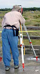
Sixty years later, Pointe du Hoc is once again the scene of an historical mission, this one aimed at preserving the memory of Rudder, his valiant commandoes and their heroic triumph against overwhelming odds. This summer, a multi-disciplinary team from Texas A&MÆs Historic Resources Imaging Laboratory will play the role of battlefield detectives as they survey and document the Pointe du Hoc site. Combining meticulous hand measuring with high-tech surveying methods like photogrammetry, total station and ground pulse radar, the team will begin creating a comprehensive site record. Their detailed maps and drawings will provide valuable references for World War II historians and for future Pointe du Hoc preservation and educational initiatives.
ōUltimately, we want to create a visualization of the site showing it as it is now, as it was on D-Day, and what it was like in the weeks preceding the Allied invasion,ö explained Richard Burt, a Texas A&M construction science professor participating in the HRIL project. ōMuch like the History Channel show, æBattlefield Detectives,Æ our team of architects, surveyors, archeologists and military historians will use forensic methodology to accurately recreate the Pointe du Hoc D-Day scenario.ö
Though designated as a Class A Historic Site by the French Government in 1955 and transferred to the care of the American Battle Monuments Commission in 1979, Burt said there has been very little historic interpretation of the Pointe du Hoc site. Furthermore, because many important areas and structures on the battlefield are quickly succumbing to erosion, the HRIL project has taken on a sense of urgency. It is a race against time and nature.
ōUnless prompt action is taken to preserve the key elements at the Pointe du Hoc Historic Site,ö Burt said, ōinformation regarding its importance to the success of the military actions on D-Day will be irretrievably lost to historians, future generations, and particularly to the memory of the brave soldiers who gave their lives there.ö
A site reconnaissance conducted last summer by the HRIL team revealed that many of the remaining buildings and structures have not been identified. And, because of erosion, the observation post that played a critically important role in the 1944 battle has been inaccessible to the public since 2001.
ōThis is troubling to Texans, and especially to Aggies,ö Burt said, ōbecause the now inaccessible observation post is the spot where the French government erected a memorial honoring Col. Rudder and his battalion.ö
Another unique link between the Pointe du Hoc battlefield and the Lone Star State was the role played in the fight by the Battleship Texas, which Burt said is responsible, in part, for the heavily cratered terrain that remains at the site today. He said the HRIL teamÆs site survey, together with analysis of wartime aerial reconnaissance photographs, will help determine which craters were dug by the battleshipÆs 14-inch guns, and which ones resulted from the heavy bombing that preceded the invasion. The maps produced by the team will also provide a valuable resource for reconstructing the Pointe du Hoc events from existing first-hand accounts of the battle.
The Texas A&M Pointe du Hoc team includes two architecture professors with extensive historic documentation experience. HRIL director David Woodcock will guide the team led by Bob Warden, who recently directed the Historic American Buildings Survey of Montezuma Castle, a prehistoric cliff dwelling in Arizona. Other Texas A&M faculty on the Pointe du Hoc team are Bruce Dickson, professor of anthropology and archaeology; Mark Everett, professor of geology and geophysics; and James Bradford, associate professor of history and the groupÆs military historian.
The HRIL team is planning to launch the next phase of their project immediately after the 60th anniversary of the D-Day invasion, on June 6, 2004. In the fanfare surrounding previous D-Day anniversaries, the Pointe du Hoc site has served as a backdrop for two U.S. presidents. On the 40th anniversary of D-Day, President Ronald Reagan stood at the now threatened observation post and recalled U.S. commandoÆs heroic feat, ōTheir mission was one of the most difficult and daring of the invasion: to climb these sheer and desolate cliffs and take out the enemy guns.ö Ten years later, at the same site, President Bill Clinton said, ōWe stand on sacred soil. Fifty years ago at this place a miracle of liberation began. On that morning, democracy's forces landed to end the enslavement of Europe.ö
Though the HRIL team has applied for funding assistance, the multi-year project is currently moving forward with small donations gathered from a variety of sources. Anyone interested in supporting the project, preserving this historically significant battlefield and honoring the sacrifice of RudderÆs heroic rangers, should contact Richard Burt at rburt@neo.tamu.edu or (979) 845-0994.
| |
|