Home
Previous Issue
Next Issue
College Home
College Calendar
Aggie Daily
- - - - - - - - - - - - - -
Media contact:
Phillip Rollfing
979.458.0442
email |
| |
| |
Spatial planning, risk assessment

Doctoral students design online mapping system
for tracking sex offenders
| |
|
A team from Texas A&M University's College of Architecture
is developing computerized mapping techniques to help police track
locations and estimate risk-levels for registered sex offenders.
"We have created a spatial planning tool that law enforcement
officers can use to locate sex offenders living in off-limits child
safety
zones," says Praveen Maghelal, doctoral student in planning
in the Department of Landscape Architecture and Urban Planning. "Geographic
information systems (GIS) technology provides a powerful means
to map the addresses of such offenders and relate these locations
to critical areas where children frequently gather."
"The system also is expected to help authorities provide timely
proximity information about sex offenders living near the site
of a child's disappearance, thus potentially contributing to quick
solutions to such crimes," adds partner Miriam Olivares, also
a doctoral student in planning.
Federal laws, such as the Sexually Violent Offenders Registration
Act of 1994 and the 1996 Megan's Law, require those convicted of
sexual crimes to register their places of residence with local
law enforcement agencies, which then notify others residing in
the neighborhood (within three blocks for subdivisions and within
a one-mile radius for non-subdivided land) of the offender's presence.
Most states also designate child safety zones near which offenders
may not live, such as around daycare providers and schools.
Tracking such offenders has proven difficult, however, due to their
mobility and to the fact that the size of child safety zones varies
between different legal jurisdictions. In Texas, child safety zones
are designated as "within 1,000 feet of premises including
schools, day-care facilities, playgrounds, public or private youth
centers, public swimming pools, and video arcade facilities, places
where children generally gather."
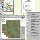
Maghelal and Olivares used the GIS process of geocoding to locate
all such facilities in Brazos County, the jurisdiction for which
this system initially was developed; then they mapped the residences
of the 164 sex offenders registered there in spring 2005. Working
with the City of Bryan, which posted this information to the Web,
the two graduate students made the resulting map available to both
county law enforcement and the general public.
"Praveen and Miriam's project was more than just a database," says
Doug Wunneburger, the research scientist who taught the GIS course
for which it was developed. "Their analysis showed that a
high percentage of registered sex offenders live in locations that
violate restrictions against proximity to child safety zones. Their
map allows members of the public to use the work as a planning
tool to determine if sex offenders live near their homes or facilities
used by their children. It can also help parole officers and sex
offenders identify areas to avoid in finding a place for such offenders
to live."
But Maghelal and Olivares did not stop at simply mapping where
registered sex offenders live. They came up with a system for categorizing
risk to communities caused by the presence of sex offenders.
"Based on the nature of a sex offender's offense, parole boards
assign a risk level of low, medium or high," Maghelal explains. "Miriam
and I have created an analysis system by overlapping and categorizing
an individual offender's area of risk with child safety zones,
which helps law enforcement gauge the cumulative risk to the community
posed by individual offenders."
The students' approach was a novel one and has been praised by
law enforcement officials.
"Prior to our study, no one had tried to understand the dynamic
effect of the presence of sex offenders on the community," says
Olivares. "Most studies had been done from the perspective
of the sex offender's location or of concentrations of multiple
registered offenders. But we looked at how to calculate for the
community the accumulated threat based upon where sex offenders
live."
The students' class project has turned into quite an enterprise.
Olivares and Maghelal have presented papers about the project at
the National Institute of Justice's Crime Mapping Research and
ESRI Conferences, at the Texas A&M Pathways Student Research
Symposium, where it was awarded first place for graduate research,
and at the university's Student Research Week, where it also won
first place for oral presentation. In addition, the web-based service
developed by the City of Bryan as a result of the student's work
has received coverage on national television. Now, Maghelal and
Olivares are hoping to work with other communities to analyze the
risk imposed due to the presence of registered sex offenders.
"I think the most interesting aspect of Praveen and Miriam's
GIS mapping and risk assessment methodology is its potential for
evaluating
the benefits of the current law-making trend to mandate large child
safety zones," notes Wunneburger.
"Can such practices help prevent sex crimes? If so, could
similar methods be applied to prevent or limit impacts of other
crimes,
such as DWI offenses? These two students have already established
their proficiency in addressing such questions."
| |
|
|
| |
|
|