|
Urban planners walk a tightrope, managing inevitable growth
while maintaining ecosystem function, weighing environmental
issues
such as preserving wetlands and water quality alongside the
task of mitigating natural hazards that threaten people. Texas
A&M University architecture professor Samuel Brody and
other researchers help provide the tools such planners need
to keep their balance.
"Here at the Environmental Planning and Sustainability
Research Unit (EPSRU) in the Hazard Reduction and Recovery Center,
we research actual problems, then feed that information to decision
makers," says Brody, a professor in the College of Architecture's
Department of Landscape Architecture and Urban Planning. "We
map, measure and analyze across space, looking at the effects
of existing policies on ecosystems. Most of our research is funded
by grants from agencies like the National Science Foundation
and the National Oceanographic and Atmospheric Administration
(NOAA). Those funds support our lab, the hub of EPSRU in which
six graduate students and one undergraduate work."
Brody, who modestly insists he owes all his success to these
students, has received a National Science Foundation (NSF) Career
Award to study the impacts of development on Texas and Florida
wetlands and coastal watersheds adjacent to the Gulf of Mexico.
"Over time, development has altered these wetlands, with
a cumulative effect of exacerbating flooding," Brody says. "We're
studying the scale of these effects, paying attention to the
type of wetland impacted and its place in the watershed."
One approach to studying wetland impacts has involved tracing
the 50,000 development permits issued in the area over a 13-year
period.
"Temporally, these permits move over the face of the landscape,
showing the degree of alteration brought about by development
and its impact on flooding," Brody explains.
The permits help trace how actual development has deviated
from original future-land-use maps adopted by country and city
jurisdictions. Brody's team used the resulting permit map to
examine factors that influencing such development patterns,
which do not conform to plans, and to isolate specific socioeconomic,
demographic and geographic variables that may have contribution
to this deviation.
"These are hard research questions," Brody says. "Wetlands
hold and store water and over time form the perfect natural
buffer to repetitive chronic flooding. With long-term degradation
of the environment from nonsustainable development patterns,
cumulative impacts may result in flooding hazards."
Brody also has worked with researchers from the George Bush
School of Government and Public Service at Texas A&M to
study climate change and people's perceptions of their risk,
comparing such perceptions to actual risk as indicated by proximity
to the coast, elevation and past events.
"We found that persons living near the coasts who had experienced
casualties from hurricanes had more accurate perceptions of
their potential risk from global-warming-induced rises in sea
level than did persons living in floodplains further inland," he
says.
And this month, he'll begin working with Sea Grant on a NOAA-funded
project to produce a planning atlas for coastal communities.
"This atlas would be available to anyone via the Internet," Brody
explains. "It would include socioeconomic, biological
and hazards data which could be queried. Users could construct
what-if scenarios as a tool to discovering ways to mitigate
potential adverse environmental impacts of proposed actions."
| |

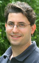
Samuel Brody, College of Architecture
|

